Project leader:
Dr. Ingo Grevemeyer
Phone: +49-431 600-2336
Fax: +49-431 600-2922
Plate re-organization in the western Mediterranean: Lithospheric causes and topographic consequence
Individual Project IP1-GE Ocean-bottom seismology in the Alboran Sea / Gibraltar Arc
Duration: 01.01.09-31.12.2011
Applicant: Dr. Ingo Grevemeyer
Sponsered by: DFG within the programme TOPO-EUROPE of the European Science Foundation (ESF)
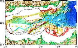
The evolution from the Western Mediterranean Sea is inherently governed by (i) plate convergence between Nubia (Africa) / Eurasia and (ii) subduction related slab-roll back. Both processes are responsible for the surface features / topography of the Alboran Sea / Rif / Betic domain and deep-seated features related to the consumption of African lithosphere. The proposed project is part of the ESF-EUROCORES programme TOPO-EUROPE and is aiming to study the interrelation between convergence and major tectonic fault zones in the Alboran Sea (Trans-Alboran-Shear-Zone – the Alboran Ridge and Yusuf Ridge pull apart basin) and Miocene subduction / deep-seated seismicity (40-150 km depth). Monitoring networks with ocean bottom seismometers (OBS) and hydrophones (OBH) will be installed in the area to record local and regional earthquakes. Two deployment periods of 6-8 month (in total one year to 16 month) are planned, resulting into three cruises (leg 1 – deployment, leg 2 – recovery plus re-deployment, leg 3 –recovery). In addition, data will be used for tomographic inversion and receiver function analysis, providing seismic constraints on the structure of crust and mantle in the Gibraltar arc area and Alboran domain.
In summary, main aims of the offshore seismological monitoring are:
a) defining the nature of terrains in the Alboran Sea, most importantly the size of the Miocene volcanic arc to assess/understand the timing of slab retreat and slab width
b) studying the nature of major fault zones in the Alboran Sea. Are they zones of weakness or are they related to terrain bounderies? Does the "patch work" of terrains in the Alboran domain governs differences in accommodating plate convergence between Eurasia-Nubia in northern Algeria and Alboran domain?
c) characterisation of mantle underlying the Gibraltar arc / Alboran domain and earthquake distribution
d) providing for the first time travel time data recorded at offshore stations from local, regional and teleseismic earthquakes to be used in tomographic inversion and to study seismotectonic processes in the region
e) defining the nature of the tomographically imaged “subducting lithosphere”