The Research Projekt SO193 MANIHIKI

The research project MANIHIKI (“Temporal, spatial and tectonic evolution of oceanic plateaus”) began in May 2007 with an expedition of the German research vessel “Sonne” to the area of the Manihiki Plateau north-east of Samoa. The project was supported by the German Federal Ministry of Education and Research (BMBF) and comprises geological, geochemical, bathymetric, and biological investigations. The research cruise started on May 19th, 2007 in Suva (Fiji) and ended on June 20th, 2007 in Apia (Samoa), and was carried out by geoscientists from the Helmholtz Centre for Ocean Research in Kiel (formerly known as Leibniz Institute of Sciences), in cooperation with scientists from other institutes in Germany, New Zealand, an Japan. Analysis of rock samples, classification of marine fauna, interpretation of geochemical, age, and bathymetric data, and publication of results were completed within 2.5 years of the cruise.


On this page, please find informations about the large plateaus in the SW-Pacific and the working area, the major objectives of the research project MANIHIKI, the methods used onboard RV Sonne, and a list of the cruise participants.


If you are intrested in more detailed informations about plate tectonics and mantle dynamics, the geochemical studies, and age dating of magmatic rocks, as well as the biological studies of SO193 MANIHIKI, click here.


Home of SO193 MANIHIKI


THE LARGE PLATEAUS IN THE SW-PACIFIC

Three large oceanic plateaus being considered as Large Igneous province (LIPs) do exist in the SW-Pacific: The Manihiki Plateau (see below), the Ontong Java Plateau ~2,200 km to the west of the Manihiki Plateau covers 1.5 million square kilometers (approximately twice as large as Turkey) and is the largest LIP on earth, and the Hikurangi LIP ( 350,000 square kilometers, similar in size to Germany) approximately 3,000 km south of the Manihiki Plateau. According to some authors, the Manihiki Plateau may have formed during the same event which caused the formation of the Ontong Java Plateau („Greater Ontong Java Event“). Other studies suggest that the Manhiki Plateau may have once been connected to the Hikurangi Plateau. The inset shows a 3D-map of the NE edge (Rapuhia Scarp) of the Hikurangi Plateau which has been mapped and sampled on RV Sonne cruise SO168 ZEALANDIA. The Rapuhia Scarp rises up to 1,000 m above the Cretaceous Pacific abyssal plain and may represent a rifted margin. The Hikurangi Plateau may have been separated in the Cretaceous by seafloor spreading at the Osbourn Trough, a paleo-spreading center.


The Ontong Java and Hikurangi Plateaus are relatively well investigated but samples and data lack from the Manihiki Plateau. However, a more detailed sample and data set form the Manihiki Plateau is essential in order to verify if the temporal and geochemical evolution of the three plateaus was similar and if they hence may result from a single magmatic „mega event“. Whether separate events or a single mega event, the volcanism associated with these three oceanic plateaus must have had a significant impact on ocean circulation, water chemistry and temperature as well as marine life in the southwest Pacific Ocean.


THE WORKING AREA MANIHIKI PLATEAU

The Manihiki Plateau is located in the SW-Pacific between ~ 3°S and ~ 16°S and ~ 159°W and ~ 169°W and covers 550,000 square kilometers (approximately the same area as France). The plateau elevates ~ 2,000 - ~4,000 m above the Creatceous Pacific sea floor at a depth of  4,000 - 5,500 m. Numerous seamounts and a couple of small islands and atolls, belonging to the Cook Islands, are situated on the plateau. The Manihiki Plateau can be subdivided into three major geomarphological units: (1) „High Plateau“ in the east, (2) „North Plateau“, and (3) „Western Plateau“. These units are seperated by deep grabens which possibly represent rift structures. The most important areas of investigation for SO193 are: the High Plateau, the North Plateau and the Western Plateau as well as the south-western edge of Plateau, the Danger Islands Troughs and the Eastern Scarp.

MAJOR OBJECTIVES OF SO193 MANIHIKI

The major objectives of the geological investigations in the frame of the research project SO193 MANIHIKI were to improve our understanding of:

(1) the age range and temporal evolution of the Manihiki Plateau, i.e. was it formed within several million years (consistent with the „classical“ model for the formation of Large Igneous Provinces [LIPs]) or over much longer time scales and did much of the plateau form during the Greater Ontong Java event?

(2) the origin of the Manihiki Plateau, i.e. has it been formed by shallow or deep magma sources or interaction of both (e.g., plume, plume-ridge interaction, impact etc.; see also plate tectonic and mantle dynamics)?

(3) the range in geochemistry, i.e. how homogeneous or heterogeneous are oceanic LIPs and how did the Manihiki Plateau develop geochemically compared to those of the Ontong Java and Hikurangi Plateaus? 

(4) the paleo-environment at the time of formation of the Manihiki Plateau, i.e. did the volcanic activity take place in shallow water conditions as suggested by prior studies for some areas of the plateau and, if so, how did the subsidence history of the Manihiki Plateau develop?

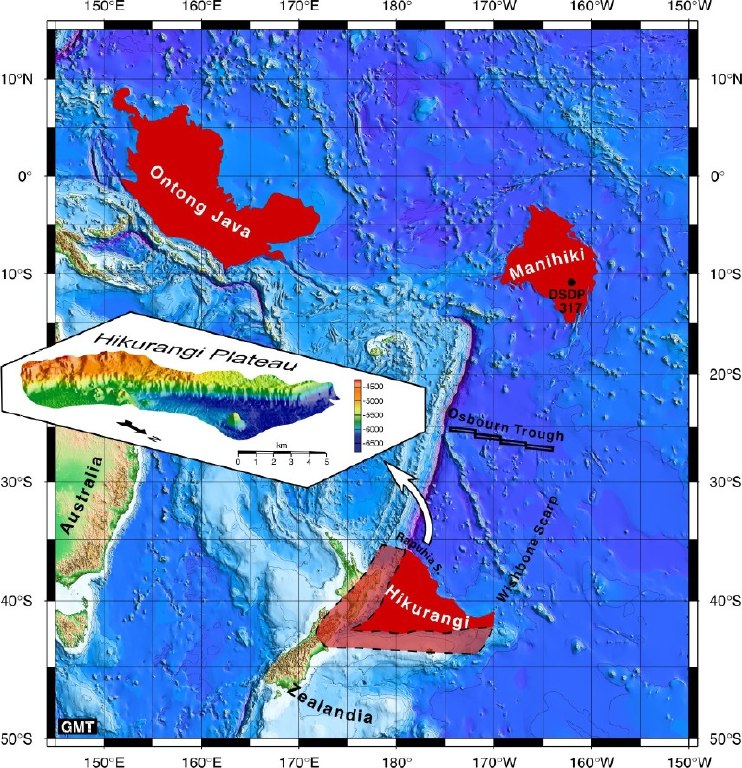
(5) whether the Manihiki Plateau was once connected to the Hikurangi Plateau and, if so, to constrain the time of the break-up of this paleo-plateau.

The integration of the results with existing data from the Manihiki, Hikurangi and Ontong Java Plateaus resulted in a new and improved model for the spatial, temporal, and magmatic evolution of the Manihiki Plateau. This approach contributed towards a better understanding of the formation of Large Igneous Provinces and the geodynamic evolution of the SW-Pacific. Furthermore SO193 MANIHIKI aimed to verify if the Manihiki Plateau possibly represents only a part of the products of a much larger magmatic event and, therefore, has been formed by a Cretaceous „mega event“ with huge magma production rates (e.g., „Greater Ontong Java Plateau Event“). Such extensive volcanism no doubt had a dramatic impact on the paleo-environment of the southwest Pacific but possibly also had implications for the mass transfer between mantle and lithosphere and consequently for the heat budget and heat flux in the Earth´s interior. Whether separate events or a single mega event, the volcanism associated with these three oceanic plateaus must have had a dramatic impact on the chemistry, temperature and life in the southwest Pacific Ocean.

Investigations of LIPs are also relevant for environmental protection, social policy, and economy. Magmatic processes associated with LIP formation cause, for example, submarine volcanic eruptions and fluid venting which influence the chemical and physical properties of sea water. A better knowledge of these magmatic processes is essential in order to understand the implications and consequences of the volcanic activity and venting for the (marine) environment.


Furthermore the diversity and the distributional patterns of the invertebrate communities were investigated in the framework of MANIHIKI. The Manihiki Plateau is a submarine archipelago, which may serve as a centre of origin for many invertebrate groups, thereby influencing other such regions through propagules (larvae and postlarval pelagic stages) of mainly sessile filter feeders dispersed by the ambient currents in the deep sea. We aimed at assessing the 'hot spot' character of the Manihiki Plateau, which  reflected in the degree of endemism of its benthic communities. We also compared the collected faunas with those found on the Hikurangi Plateau, which was comprehensively sampled during SO168. 

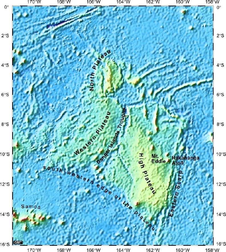
The Manihiki Plateau is vertically structured and comprises seamounts, slopes and deep-sea plains. The plateau's species composition should reflect this morphology with higher endemism rates on top of the seamounts. Comprehensive sampling of all possible habitats on the plateau and subsequent analysis of their diversity gave us an idea about the biogeography of benthic invertebrates in the study area and may also helped to assess the function of the plateau as a centre of origin for other communities in the Pacific. Due to their expected abundances, we focused on invertebrate key groups, such as sponges (Porifera), moss animals (Bryozoa), lamp shells (Brachiopoda), Kinorhyncha and Loricifera, representing both macro- and meiofaunal elements.


SAMPLING AND MAPPING WITH RV SONNE

The research vessel "Sonne", 98 m long and 4734 metric tons, is one of the 4 large German research vessels together with the R/V “Polarstern”, R/V “Meteor” and the new R/V „Maria S. Merian“. The Sonne primarily operates in the Indian and Pacific Oceans. The ship, built in 1969 as a stern-fishing trawler and converted in 1977 into a research vessel, was completely reconstructed in 1991 and still ranks as one of the most efficient research vessels.


The schematic sketch illustrates methods for sampling magmatic rocks on the ocean floor. Dredges are similar to large steel buckets or frames with steel teeth at their openings, which are dragged along the ocean floor and thereby scraping off rocks the ocean floor into the dredge (see left). We use dredges to sample submarine volcanic structures. The TV grab consists essentially of a set of steel jaws with a video camera in the center, which transmits pictures of the ocean floor. When scientists identify a suitable object for sampling on the monitor, they can close the hydraulic jaws by remote control around the object and then heave it on board. The TV grab is more suitable for selective sampling of loose or soft rocks or even zoological material, whereas dredging can break off rocks from the basement and usually recovers a larger amount of sample material. For biological sampling a „multi corer“ will be deployed which allows sampling of undisturbed sediments from the surface of the ocean floor. When the multi corer touches the ocean floor, a weight presses some tubes up to ~40 cm deep into the sediment. As soon as the tubes have pentrated the sediment their lower openings will be closed. Afterwards the multi corer will be hieved on board and the „blanked“, undisturbed sediment cores can be drawn from the tubes.

The sampling areas are pre-selected based on available bathymetric and literature data. Since these data in most cases were not adequate to find suitable sites for sampling, the seafloor was first mapped using a multi-beam echosounding system. By contrast to “normal” echosounding systems, which send one beam vertically beneath the vessel, multi-beam echosounding systems operate with many beams which map a swath beneath the vessel. The SIMRAD EM120 system of RV Sonne operates with 191 beams and is able to map a wide stripe of the seafloor below. The resulting data are immediately processed and are displayed onboard. However, bathymetric mapping is not only important for the identification of suitable sampling sites. Maps and 3D projections based on multi-beam data also provide important informations for various scientific investigations as examplified below.

The figure to the left shows a seamount off New Zealand mapped on a prior RV Sonne expedition using the SIMRAD EM120 multi-beam echosounding system. The seamount is marked by a large plateau in its top area which has been formed by erosion at sea level (although now located in ~2,000 m water depth). This observation is consistent with the seamount being a former island volcano that was eroded to sea level after the volcanic activity ceased and afterwards subsided by ~2,000 m. Many relatively small volcanic cones are located on the erosional plateau. These volcanoes must have formed after erosion of the former island and subsidence below sea level since they are obviously not eroded. In summary, mapping of this seamount provided important informations on its evolution as, for example, that the seamount has been a former island volcano and that at least to stages of volcanic activity occured at different times („shield stage“ and „post-erosional-stage“).


Scientific party of SO 193 MANIHIKI cruise (in alphabetical order)