Fresh water below the sea floor
Extensive fresh water reservoir discovered off the coast of New Zealand
Drinking water is a very precious commodity in many regions of the world, e.g. such as the Mediterranean or the Middle East. For this reason, new freshwater reservoirs have been sought for quite some time. It has been known for some years now that there are freshwater reservoirs below the seabed near the coast. Some of them are fed from terrestrial sources. Within the MARCAN project, which was funded by the European Research Council, and additional funding resources from the New Zealand Ministry of Innovation and Employment, the US National Science Foundation and the German Research Foundation, an international team has developed new methods to find and map freshwater below the seafloor. Within the project, the researchers discovered an extensive water reservoir off the South Island of New Zealand.
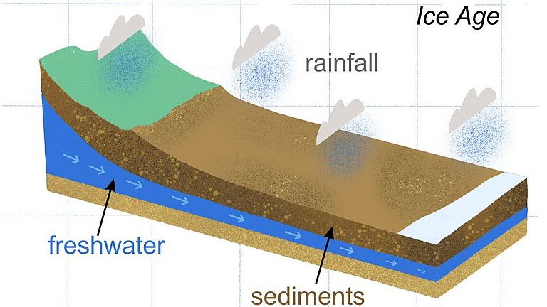
"The freshwater is located in sediments only 20 meters below the seafloor, which makes it one of the shallowest reservoirs in the world", explains Prof. Dr. Aaron Micallef, first author of the study from the University of Malta, who is currently working at GEOMAR Helmholtz Centre for Ocean Research Kiel. "It extends up to sixty kilometres from the coastline and comprises up to two hundred cubic kilometres of water", Prof. Micallef continues. The freshwater system shows complex variations in form and salinity over its entire extent, which makes its mapping difficult, says the Maltese scientist.
The freshwater originates from precipitation and is currently partially replenished by groundwater flow from the coastline. However, most of the fresh water was stored in the reservoir off the coast during the last three ice ages, when sea levels were more than a hundred metres lower than today.
"Our discovery was the result of integrating seismic and electromagnetic surveying in combination with numerical modelling", explains Dr. Marion Jegen, co-author of the study from GEOMAR. "This novel approach developed by us can characterize offshore freshwater systems in exceptional detail and can significantly revise estimates of their occurrence and volume when applied globally", Dr. Jegen continues. The results are important in view of the potential use of offshore freshwater systems as a new source of drinking water, the management of coastal aquifers extending offshore, and the role they play in the chemistry and biology of the ocean, explains the geophysicist from Kiel.
The results of the study have now been published in the international journal Nature Communications.
Reference:
Micallef, A., M. Person, A. Haroon, B. A. Weymer, M. Jegen, K. Schwalenberg, Z. Faghih, S. Duan, D. Cohen, J. J. Mountjoy, S. Woelz, C. W. Gable, T. Averes, and A. Kumar Tiwari, 2020: 3D characterisation and quantification of an offshore freshened groundwater system in the Canterbury Bight. Nature Communications,
https://doi.org/10.1038/s41467-020-14770-7


