Ocean currents likely to carry oil to Atlantic coast
June 3, 2010. Boulder, USA/Kiel, Germany. A detailed computer modeling study released today indicates that oil from the massive spill in the Gulf of Mexico might soon extend along thousands of miles of the Atlantic coast and open ocean as early as this summer. The modeling results are captured in a series of dramatic animations produced by the the National Center for Atmospheric Research (NCAR) and collaborators.
NOTE: The research was supported by the National Science Foundation, NCAR’s sponsor, and by the Department of Energy. The results were reviewed by NCAR elsewhere, although not yet submitted for peer-review publication.
“I’ve had a lot of people ask me, ‘Will the oil reach Florida?’” says NCAR scientist Synte Peacock, who worked on the study. “Actually, our best knowledge says the scope of this environmental disaster is likely to reach far beyond Florida, with impacts that have yet to be understood.”
The computer simulations indicate that, once the oil in the uppermost ocean has become entrained in the Gulf of Mexico’s fast-moving Loop Current, it is likely to reach Florida's Atlantic coast within weeks. It can then move north as far as about Cape Hatteras, N.C. with the Gulf Stream, before turning east. Whether the oil will be a thin film on the surface or mostly subsurface due to mixing in the uppermost region of the ocean is not known.
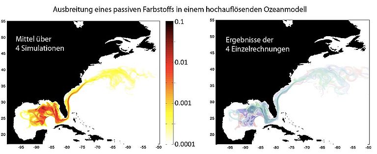
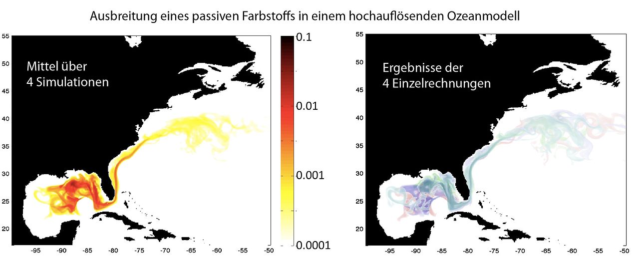
The scientists used a powerful computer model to simulate how a liquid released at the spill site would disperse and circulate, thereby producing results that are not dependent on the total amount released. The scientists tracked the rate of dispersal in the top 65 feet of the water and at four additional depths, with the lowest being just above the sea bed.
“The modeling study is analogous to taking a dye and releasing it into water, then watching its pathway,” Peacock says.
The dye tracer has no actual physical resemblance to true oil. Unlike oil, the dye has the same density as the surrounding water, it does not coagulate or form slicks, and it is not subject to chemical breakdown by bacteria or other forces.
Peacock and her colleagues stress that the simulations are not a forecast because it is impossible to accurately predict the precise location of the oil weeks or months from now. Instead, the simulations provide an envelope of possible scenarios for the oil dispersal. The timing and course of the oil slick will be affected by regional weather conditions and the ever-changing state of the Gulf’s Loop Current—neither of which can be predicted more than a few days in advance. The dilution of the oil relative to the source will also be impacted by details such as bacterial degradation, which are not included in the simulations.
What is possible, however, is to estimate a range of possible trajectories, based on the best understanding of how ocean currents transport material. The oil trajectory that actually occurs will depend critically both on the short-term evolution of the Loop Current, which feeds into the Gulf Stream, and on the state of the overlying atmosphere. The flow in the model represents the best estimate of how ocean currents are likely to respond under typical wind conditions.
Picking up speed
Oil has been pouring into the Gulf of Mexico since April 20 from a blown-out undersea well, the result of an explosion and fire on an oil rig. The spill is located in a relatively stagnant area of the Gulf, and the oil so far has remained relatively confined near the Louisiana and Alabama coastlines, although there have been reports of small amounts in the Loop Current.
The model simulations show that a liquid released in the surface ocean at the spill site is likely to slowly spread as it is mixed by the ocean currents until it is entrained in the Loop Current. At that point, speeds pick up to about 40 miles per day, and when the liquid enters the Atlantic’s Gulf Stream it can travel at speeds up to about 100 miles per day, or 3,000 miles per month.
The six model simulations released today all have different Loop Current characteristics, and all provide slightly different scenarios of how the oil might be dispersed. The simulations all bring the oil to south Florida and then up the east Coast. However, the timing of the oil’s movement differs significantly depending on the configuration of the Loop Current.
The scenarios all differ in their starting conditions, a technique used in weather and climate forecasting to determine how uncertainty about current conditions might affect predictions of the future.
Additional model studies are currently under way, going farther out in time, and will indicate where the oil spill might head once well out in the Atlantic.
“We have been asked if and when remnants of the spill could reach the European coastlines,” says Martin Visbeck, a member of the research team at IFM-GEOMAR, Kiel, Germany. “Our assumption is that the enormous lateral mixing in the ocean together with the biological disintegration of the oil should reduce the pollution to levels below harmful concentrations. But we would like to have this backed up by numbers from some of the best ocean models.”
The scientists are using the Parallel Ocean Program, which is the ocean component of the Community Climate System Model, a powerful software tool designed by scientists at NCAR and the Department of Energy. They are conducting the simulations at supercomputers based at the New Mexico Computer Applications Center and Oak Ridge National Laboratory.
Disclaimer:
The University Corporation for Atmospheric Research manages the National Center for Atmospheric Research under sponsorship by the National Science Foundation. Any opinions, findings and conclusions, or recommendations expressed in this publication are those of the author(s) and do not necessarily reflect the views of the National Science Foundation or the Department of Energy.
Contacts:
Dr. Andreas Villwock (Communication & Media): Phone: +49-431 600-2802,
avillwock@geomar.de