Project leader
Dr. Ingo Grevemeyer
Phone: +49 431 600-2336
Fax: +49 431 600-2922
e-mail: igrevemeyer(at)geomar.de
TYRRENIan sea Seismic experiment on continental break-up and structure of conjugated rifted margins
Duration: 01.01.2010-31.12.2012
Applicants: Priv. Doz. Dr. Ingo Grevemeyer, Prof. Dr. Christian Berndt
Sponsered by: Deutsche Forschungsgesellschaft (DFG)
Rifted margins are areas of dense population and host major energy resources in the sub-surface. However, the geological processes that control the formation of continental margins are yet not well understood. It is the aim of the proposed project to constrain the temporal and spatial distribution of stretching and crustal thinning of conjugate margins to gain insight into the geological processes underlying continental margin formation. The Tyrrhenian Basin is a confined rift basin with active rifting at its edges and it has the advantage of well preserved, un-deformed conjugate margins in its central part. This makes it an ideal natural laboratory to study the formative processes of rifted margins.
We propose a collaborative project with partners from Spain and Italy to address these questions in a multi-disciplinary project. New data will be acquired during a two ship operation in April 2010. The Spanish R/V Sarmiento de Gamboa will collect multi-channel seismic (MCS) data and operate airguns for seismic refraction and wide-angle work. Ocean-bottom stations for the refraction work will be deployed and recovered from the Italian vessel R/V Urania. Several geophysical transects will cross the Tyrrhenian Basin, sampling conjugate margins that have been formed under different amount of stretching. The comparison of the crustal and upper mantle structure derived from seismic reflection and seismic refraction data along different transects will permit to unravel the evolution of the processes of continental margin formation by trading space (different areas with different stretching factors) for time (evolution of extension).
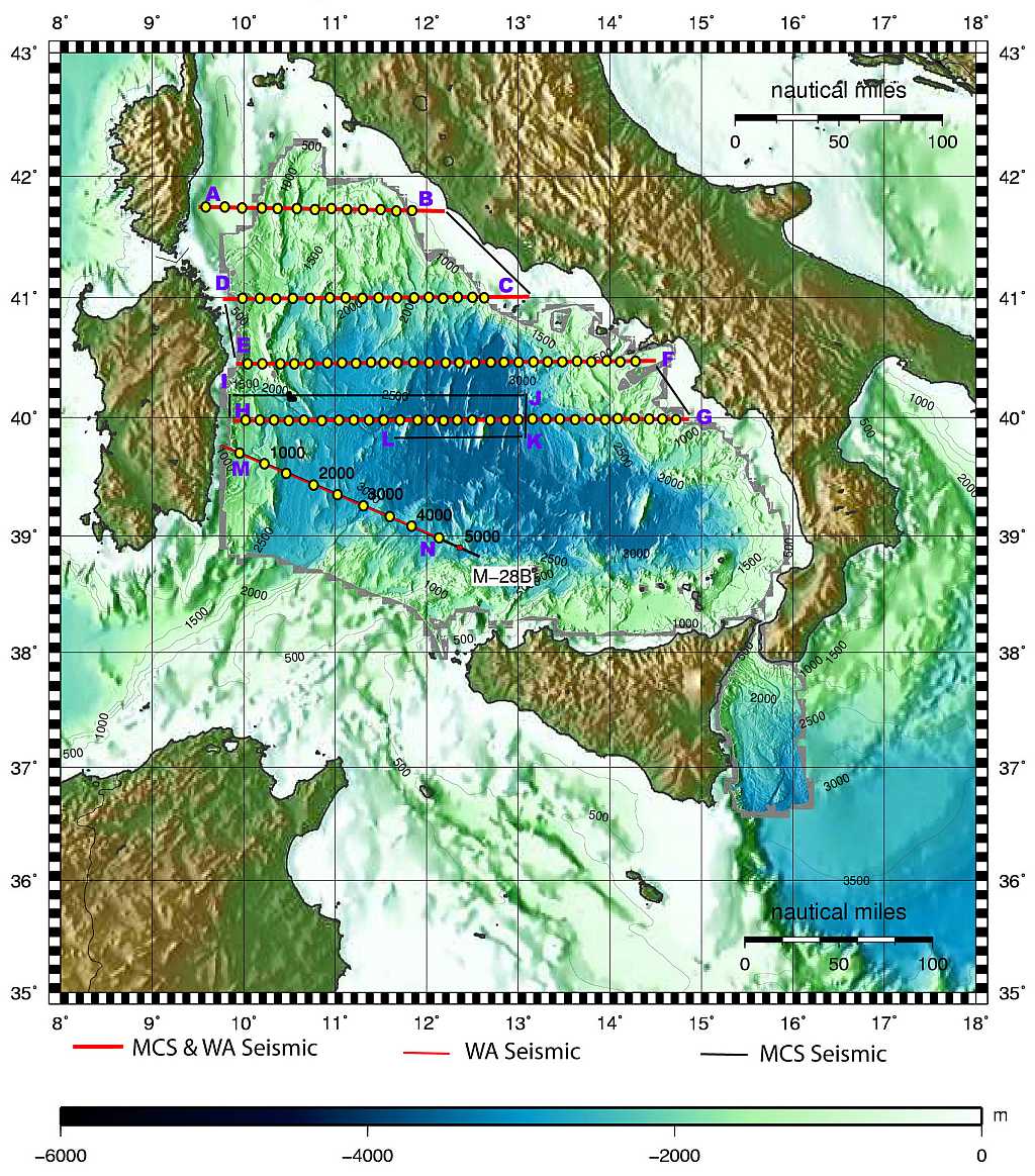
Bathymetric map of the working area of MEDOC cruise (the Thyrrenian Sea). The different seismic profiles to be acquired and corresponding waypoints are labelled A-B to M-N. The red lines show the WAS profiles to be acquired during the first phase and the MCS profiles to be acquired in the second phase. The black lines correspond to those profiles that will be acquired only with MCS. The yellow dots show the approximate locations of the OBS deployment (this may change slightly depending on the detailed bathymetry).