WP1: Seafloor dynamics and associated hazards

Coordinator: Prof. Dr. Christian Berndt
(Deputy: Dr. Armin Freundt)
Scientific Questions
The opening and closing of ocean basins and the concomitant creation at mid-ocean ridge spreading centres, modification through alteration, tectonic and volcanic processes, and destruction at subduction zones of seafloor are the major processes, which modify the lithosphere and asthenosphere of our planet. Our scientific questions relate to how these processes operate, what chemical and structural changes they cause to the crust and underlying mantle beneath the ocean basins and their margins and the threats resulting from these dynamic processes to humankind. The range of scientific questions we will study is extensive, some examples are:
- What are the recurrence times and ash cloud distributions of explosive eruptions within the ocean basins, e.g. Iceland?
- What is the crustal configuration of the African-Eurasian plate boundary and how likely is it that another Lisbon 1755 earthquake may occur?
- How tsunamogenic are sector collapses of volcanic ocean islands and do they indeed pose a serious threat to European coasts?
- How does the ocean crust age and alter after its creation?
Contents and Goals
Research Highlight: Ageing of the Atlantic lithosphere: Although the processes occurring at constructive and destructive plate boundaries have been relatively well studied, the vast region in between has, with the exception of regions influenced by intraplate volcanism, traditionally been regarded as "passive" or "inactive". Evidence (including signs of active upflow of crustal fluids along ancient fracture zones and over basement highs and off-axis hydrothermalism in areas such as Logatchev and the Trans-Atlantic Geotraverse (TAG) studied in the 1980’s) is accumulating and suggests that this is not the case. The oceanic crust may represent a huge, slow reactor in which the lithosphere and hydrosphere exchange energy and material. We intend to initiate a Transregio-SFB (Collaborative Research Centre) proposal to be submitted to the DFG at the start of the programme period (together with the Universities of Kiel, Bremen and Hamburg) to investigate hypotheses such as: (1) Plate construction processes at slow-spreading ridges are not constant over time but produce a heterogeneous crust on the regional and ocean basin scale, significantly affecting the style and results of lithosphere/ocean exchange and possibly of mineral deposit formation. (2) Crustal fractures experience repeated seismic activity and therefore provide major pathways for fluids to move through consolidated oceanic sediments, the igneous crust and into the upper mantle. This keeps the oceanic plates an open system for energy and material exchange with the ocean during their entire existence, which affects both long-term ocean chemistry and the chemical composition of the lithosphere entering the subduction zone. These processes also have major ramifications for subseafloor life. (3) Venting of crustal fluids provides oases for chemosynthetic life that are abundant on the deep-sea floor in intraplate regions, providing a solution for the apparent paradox of the relatively well-mixed genomic signature of chemosynthetic species over wide geographic areas contrasted with the relatively few known sites of seep or vent activity. This Transregio will involve contributions from all Topics within OCEANS and will have strong links to the universities in Kiel and Bremen.
Further research highlights are:
Explosive eruptions from volcanoes in and on the margins of ocean basins can pose a significant economic and health risk to humans. Volcanic eruptions in the North Atlantic, such as the recent Eyjafjallajökull (2010) and Grimsvötn (2011) outbursts on Iceland, which disrupted European and intercontinental air traffic for several weeks, pose a direct financial threat to Europe and the North Atlantic region. Volcanic eruptions in the Canary, Cape Verde and Azores Island groups, as evident from paleo-eruptive products, could also pose similar threats. In order to improve our probability estimates of future ash cloud risks from such volcanoes, we need to refine our knowledge of the size and timing of former eruptions to the scale of decades/years. The history of ocean island volcanism has been extensively studied on land, but soil-tephra profiles generally have a low temporal resolution due to very slow accumulation rates of soils and can be disturbed by intense erosion. Offshore sediment accumulation rates are generally much higher, providing a much better potential to preserve and clearly separate individual ash beds. In a pilot project attempting to achieve a high-resolution reconstruction of the temporal evolution of Icelandic volcanism, we will study sediment cores from the southern and eastern sectors of the Icelandic shelf, the region where we expect tephras and ash from eruptions, which most likely affected Europe, to be deposited. Coring into ocean floor sediments will be performed at sites where sedimentation rates are high enough to preserve individual layers from even moderate eruptions (Eyjafjallajökull-scale), which are not preserved on land. The data from tephras offshore Iceland will be statistically evaluated in an attempt to reveal a temporal regularity of the eruptions and/or periodic reactivation of their source volcanoes. The data will be placed into an internationally accessible database that will be set up as part of the Earth System Knowledge Platform (ESKP) of the Research Field Earth and Environment of the Helmholtz Association (see 2.1.1). A more detailed record of volcanic eruptions on Iceland will also help further constrain magma storage conditions, the reasons for the high explosivity of Icelandic volcanoes and the input of climate-relevant volcanic gases into the atmosphere. Climate modelling of large tropical volcanic eruptions of the last millennium revealed significant changes of the coupled atmosphere-ocean system in the North Atlantic (NAO and AMOC, see Topic 1). However, less is known about the climate effects of volcanic eruptions like Iceland at high-latitudes. Here, we want to investigate in particular how strong the climate effects of Icelandic volcanic eruptions in the past and present are depending on a) their explosivity, b) their sulphur and halogen mass release to the stratosphere and c) the season of the eruption.
Earthquakes along the Eurasian-African plate boundary have caused catastrophic damage and fatalities in the past, but an assessment of the earthquake potential along this plate boundary is hampered by its complex geodynamic nature. Using experience gained through SFB574, we will use a unique combination of wide angle and 3D seismic experiments as well as electromagnetic soundings to study the plate boundary. One focus site will be the Gulf of Cadiz, where the 4mm/year NW-SE convergence between the Eurasian and African plates is accommodated along the poorly-defined plate boundary over a 200 km broad, tectonically-active deformation zone. The region has generated large earthquakes and tsunamis, such as the 1969 Mw=7.9 Horseshoe Abyssal Plain earthquake and the November 1, 1755 Great Lisbon earthquake with an estimated magnitude of Mw~8.5, the largest ever reported European seismic event. In bathymetric data, a network of shear structures that evokes the development of an incipient strike-slip fault system marks the region. In order to improve our estimates of the probability for future earthquakes, we will compile an inventory of fault zones in the Gulf of Cadiz and Horseshoe Abyssal Plain using both new seismic imaging and local earthquakes studies to relate imaged faults to earthquake occurrence. We will also use frequency-size relationships of seismic events as an indicator of potential future hazards. Other focus sites along the Eurasian-African plate boundary will be the Adriatic Sea, the Straits of Messina and the Aegean Sea. Additionally, earthquakes will be the focus of the GEOMAR contribution to the GFZ programme Geosystem, in which an onshore-offshore observatory will be installed off the coast of northern Chile, in this case to study mega-thrust rather than strike-slip seismo- and tsunamogenic earthquakes.
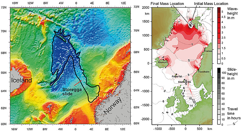
Submarine landslides on most continental margins or volcanic ocean islands can affect both coastal communities and seabed installations. The geological and geotechnical processes controlling slope stability are still so poorly understood that some of the landslides threatening expensive offshore installations could even be triggered by the very seabed engineering itself. We aim to quantify the change of slope stability caused by exploitation of shallow buried hydrocarbon resources such as gas hydrate, and also the tsunamogenic potential of landslides from ocean islands. In close collaboration with IFREMER within the European FP7 Midas project, we will lead a work package using 3D seismic experiments and geotechnical measurements to investigate the slope stability effects of potential gas hydrate extraction in the Black Sea [link to WP2]. Building on our involvement in IODP Leg 340 off Montserrat, where we have collected the first 3D seismic survey ever on volcanic island sector collapse deposits, we will attempt to establish the extent of disintegration, maximum velocities and size of individual slide events on this active volcanic flank. These findings will be integrated with results from a recently proposed seismic/MeBo (MeBo= Sea floor drill rig) cruise with the University of Bremen to the same area and feed into numerical modelling of tsunami generation and tsunami propagation to assess the hazard potential of such landslides. We will cooperate closely with the University of Kiel on studies of submarine mass wasting.