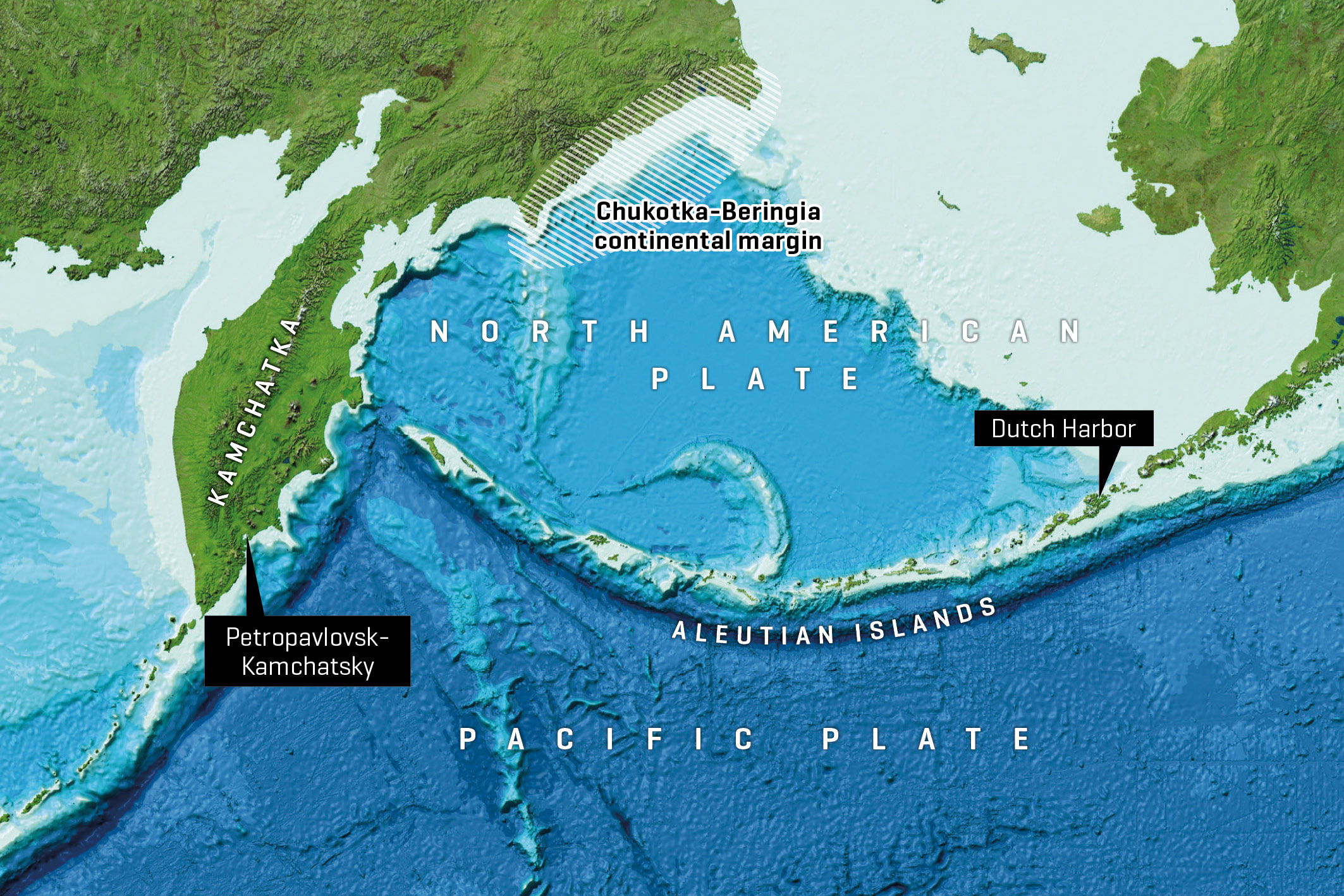
Between Alaska (USA) and Kamchatka (Russia) lies a chain of islands and underwater volcanoes stretching over more than 3,000 kilometres: the Aleutian Islands. Their rocks tell the story of one of the Earth’s most important plate boundaries, as this is where the Pacific Plate subducts beneath the North American Plate.
Illustration: GEOMAR, Image reproduced from the GEBCO world map 2014, www.gebco.net
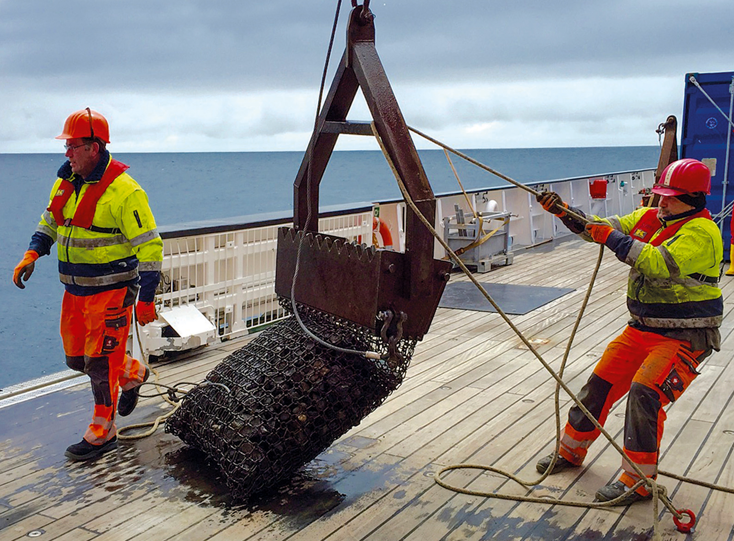
Picture of a dredge containing rock samples from the base of the Aleutian Islands recovered during SO249/1 Bering cruise.
Photo: Kaj Hoernle, GEOMAR

Russian and German scientists describing rock samples. Samples for the study were collected during the research cruises KALMAR SO201 and BERING SO249, as well as an expedition to the Russian Komandorsky Islands of Medny and Bering.
Photo: Kaj Hoernle, GEOMAR
![[Translate to English:] x](/fileadmin/content/service/presse/Pressemitteilungen/2026/38_Aleuten_Hoernle/PastedGraphic-4.png "[Translate to English:]")
[Translate to English:]
Probenahmestellen am Meeresboden, die auf vier Fahrten des Forschungsschiffs SONNE untersucht wurden: An 224 Standorten wurden Proben entnommen, an zwei Dritteln der Standorte wurden vulkanische Gesteine geborgen. Rote Punkte kennzeichnen Standorte, an denen magmatische Gesteine geborgen wurden, gelbe Punkte Sedimentgesteine.
Grafik:
One of the Earth’s Most Important Plate Boundaries Is Older than Previously Thought
Subduction of the Aleutian Islands began at least 56 million years ago
Between Alaska (USA) and Kamchatka (Russia) lies a chain of islands and underwater volcanoes stretching over more than 3,000 kilometres: the Aleutian Islands. Their rocks tell the story of one of the Earth’s most important plate boundaries, as this is where the Pacific Plate subducts beneath the North American Plate. Until now, it was not clearly established when this subduction zone formed. Researchers from Germany, Russia and the USA have now shown that this occurred at least 56 million years ago – significantly earlier than previously thought. The new age places the onset of Aleutian subduction at the beginning of a major reorganisation of plate motions across the Pacific.
“The Aleutian Islands tell a much older tectonic story than we had previously assumed,” says lead author Prof. Dr Kaj Hoernle, head of the Petrology and Geochemistry Group at GEOMAR Helmholtz Centre for Ocean Research Kiel. “According to our findings, the onset of subduction represents a key event that marked the beginning of a major, approximately ten-million-year-long period of plate restructuring.” These tectonic and magmatic processes may also have contributed to global climate events in the late Palaeocene and early Eocene.
Ancient rocks from a remote island arc
To reconstruct the early history of the Aleutian Arc, the team collected rock samples from key parts of the island chain and its submarine basement. These samples were collected during the research cruises KALMAR SO201 and BERING SO249, as well as an expedition to the Russian Komandorsky Islands of Medny and Bering. This enabled both the American and Russian parts of the Aleutian Islands to be systematically investigated for the first time.
The researchers then determined the age of the rocks using two independent dating methods: uranium–lead dating of zircon crystals and argon–argon dating of volcanic rocks and minerals. The result was clear: the oldest traces of subduction are at least 56 million years old. The process thus began much earlier than many previous models had suggested.
This earlier age is important because it places the birth of the Aleutian subduction zone at the start of a major chain of tectonic events and a reorganisation of plate motions across the Pacific. During this interval, several subduction zones and volcanic arcs around the Pacific formed, a spreading centre (mid-ocean ridge) was subducted and a large igneous province collided with the North American margin. The Aleutian Arc therefore appears to represent one piece of a much larger tectonic puzzle.
A possible link to ancient global warming
It is particularly interesting that the newly determined date coincides with the Palaeocene–Eocene Thermal Maximum (PETM). At that time, the Earth experienced one of the most extreme natural warming events in its recent history, with global mean temperatures rising by more than five degrees Celsius over a geologically short period of about 10,000 to 15,000 years. It was not until around 150,000 years later that temperatures returned to levels similar to those before the start of the PETM.
The authors emphasise that a direct causal link with the formation of the Aleutian subduction zone cannot yet be proven. However, the timing is striking. The researchers discuss whether the formation of large subduction zones could have contributed to carbon release through volcanism, hydrothermal activity or uplift of shallow marine basins. Such processes may have transferred large amounts of carbon into the ocean and atmosphere.
For now, this remains a scientific hypothesis that requires further investigation. Nevertheless, the study suggests that the birth of major subduction zones may deserve more attention as a possible trigger or amplifier of ancient global warming events.
Original publication:
Hoernle, K., Jicha, B., Portnyagin, M., Zahirovic, S., Müller, D., Hauff, F., Timm, C., Höfig, T., Yogodzinski, G., Guillong, M., Berndt, C., Savelyev, D., Bezard, R. & Baranov, B. (2026): Tectonic and climatic implications of the Aleutian Arc initiation ≥56 million years ago. Nature Communications.
https://doi.org/10.1038/s41467-026-73363-y
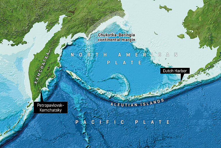
Between Alaska (USA) and Kamchatka (Russia) lies a chain of islands and underwater volcanoes stretching over more than 3,000 kilometres: the Aleutian Islands. Their rocks tell the story of one of the Earth’s most important plate boundaries, as this is where the Pacific Plate subducts beneath the North American Plate.
Illustration: GEOMAR, Image reproduced from the GEBCO world map 2014, www.gebco.net

Picture of a dredge containing rock samples from the base of the Aleutian Islands recovered during SO249/1 Bering cruise.
Photo: Kaj Hoernle, GEOMAR

Russian and German scientists describing rock samples. Samples for the study were collected during the research cruises KALMAR SO201 and BERING SO249, as well as an expedition to the Russian Komandorsky Islands of Medny and Bering.
Photo: Kaj Hoernle, GEOMAR
![[Translate to English:] x](/fileadmin/_processed_/e/e/csm_PastedGraphic-4_2a3d1dac25.png "[Translate to English:]")
[Translate to English:]
Probenahmestellen am Meeresboden, die auf vier Fahrten des Forschungsschiffs SONNE untersucht wurden: An 224 Standorten wurden Proben entnommen, an zwei Dritteln der Standorte wurden vulkanische Gesteine geborgen. Rote Punkte kennzeichnen Standorte, an denen magmatische Gesteine geborgen wurden, gelbe Punkte Sedimentgesteine.
Grafik: