
Telephone: +49 431 600-2324
E-Mail: dlange@geomar.de
DFG funded research project LIGURIA
Linking the deep structure to surface deformation:
Body wave tomography of the Ligurian Sea and South-Western Alps
The Alpine orogenic belt, which represents the scientific focus of SPP 4D-MB, is characterized by complex tectonic history resulting from the subduction and collision of small oceanic and continentaldomains, trapped between the major European and African plates that are converging since the Cretaceous.
The Ligurian Basin is a back-arc basin that opened in the Oligo-Miocene due to the the southeastward trench retreat of the Apennines-Calabria-Maghrebides subduction zone, which also triggered the opening of the adjacent western Mediterranean basins. The Ligurian Sea is also located at the transition between the Alps and Alpennines, where the subduction polarity switches and orogenic style changes. Moreover, the nature of crust and mantle, especially in the centre of the basin, is still debated. Thus it is a key area to study mountain building processes and especially extension processes in an overall convergent setting.
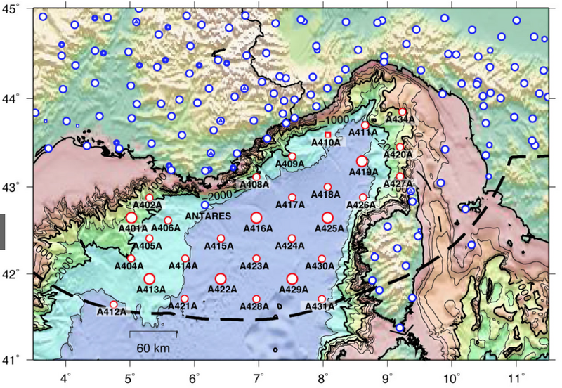
The LIGURIA project will specifically harvest the rich data set of the marine component of AlpArray (LOBSTER) to extract a maximum of information from the OBS data. The 23 LOBSTER OBS comprises the offshore component of the AlpArray seismic network to define subsurface structures at the transition from the Western Alps to the Apennines and to improve our understanding of the 3D-geometry of the system and its kinematics.
The project will start at the End of 2020 and will use body waves from primary and secondary arrivals (P, S) from OBS and AlpArray permanent and temporary stations to invert for velocity models of the Ligurian Sea and surrounding. The arrival times used will be from the following sources a.) airgun shots registered on the LOBSTER and landstations. b.) local seismicity during the deployment of the LOBSTER stations and c.) arrivals listed in the ISC catalog since the year 2000.
Using the three-dimensional velocity structure will allow extracting information of the distribution and nature of the structural units, in particular distinguishing between continental crust, hyper-extended continental crust, serpentinized mantle, and oceanic crust. Shear wave arrivals and models will contribute to assess the degree of serpentinization (i.e. ‘hydration’) of mantle rocks.
Waves travelling just below the crust-mantle boundary (MOHO) allow determining the velocity of the uppermost mantle and yield information on the thermal and tectonic history of the upper mantle. These waves (refracted waves) allow inverting for transverse anisotropy for the uppermost mantle. We hypothesize that stretching of the crust should have modified the mantle flow and hence the fast polarization directions provide information on the width of the extensional zone at depths below the MOHO.
The obtained results from the velocity models will be interpreted in relation to gravity data, sediment information, and geomorphology. In the last year of the project balancing techniques will be applied from our cooperation partners (FU-Berlin, Prof. Eline Le Breton) to quantify the amount of continental extension along those profiles. Timing of extension can be constrained with the age of syn- and post-rift sediments.