Project Leaders:
Dr. Jörg Bialas
Phone: +49 431 600 2329
Dr. Ingo Klaucke
Phone: +49 431 600 2335
CHatham RIse Methane Pockmarks
Mechanism of formation of pockmarks at the southern Chatham Rise and their influences on gashydrate stability, benthic habitat and climate
Duration: 01/01/2012-28/02/2015
Sponsored by: BMBF
Applicants: Dr. Jörg Bialas, Dr. Ingo Klaucke, Prof. Christian Berndt
The main objective of the CHRIMP project is to study pockmarks on the Chatham Rise, which is located East of New Zealand’s South Island. These pockmarks are of variable size, but some of them are particularly large with up to 10 km in diameter. Although the detailed mechanisms of pockmark formation are still under debate, these generally sub-circular to slightly elongated depressions on the seafloor are related to the expulsion of methane gas from the subsurface. Methane is one of the most aggressive greenhouse gases driving climate change, but the amount and the dynamics of natural methane reservoirs and sources, such gas hydrate layers along the continental margins, are unfortunately still not completely understood. However, improving our understanding and modelling of climate dynamics requires detailed quantitative knowledge of natural methane reservoirs and sources, such as the widespread gas hydrate deposits of the continental margins. One of the goals of the CHRIMP project is therefore to determine whether gas hydrates played a role in the formation of the pockmarks on Chatham Rise. Pockmarks and other manifestations of methane seepage at the seafloor are a widespread phenomenon, but we know that at present only seeps from shallow water contribute methane directly to the atmosphere. For the geological past much higher methane flux values have been inferred (for example the Palaeocene/Eocene Thermal Maximum (PETM) at about 55 million years ago). Did the giant pockmarks on the Chatham Rise form by the massive dissociation of gas hydrates and consequently had a profound impact on bottom fauna, ocean chemistry and climate? In order to answer these questions a multidisciplinary research cruise with RV SONNE (cruise SO226) will depart from Auckland on January 7th, 2013 and arrive in Wellington on March 1st, 2013. The team of scientists from Germany, New Zealand and the USA will map the area of the pockmarks with high-resolution geoacoustic systems, collect seismic profiles, sample the seafloor for geochemical, paleoceanographic, geotechnical and biological studies and make detailed observations of the seafloor using a towed video camera
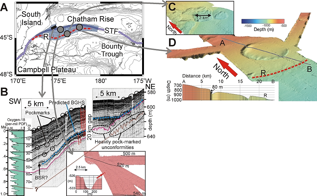
Legend: A) The working area, in grey is shown the known extension of the pockmark area. STF: Subtropical Front. R: Escarpment (Davy et al., 2010).
B) Pockmarks in 500-700 m water depth. Parasound profile and correlation with global δ 18O profiles (Lisiecki and Raymo, 2005). Buried pockmarks correlate with δ18O maxima. The predicted depth of the base of the gas hydrate stability (BGHS) corresponds for a wide range of water depth with a seismic reflection that is interpreted as bottom simulating reflector (BSR).
Inset: Seafloor morphology c) Example of a large, irregular pockmark d) Seafloor depression with ~10 km in diameterr. R: Escarpment