Project leader:
Dr. Ingo Grevemeyer
Tel.: +49 0431 600 2336
Fax: +49 0431 600 2922
Co-applicants:
Prof. Dr. Ernst Flüh
Tel.: +49 0431 600 2328
Fax: +49 0431 600 2922
Dr. Wilhelm Weinrebe
Tel.: +49 0431 600 2281
Fax: +49 0431 600 2922
TOnga Thrust earthquake Asperity at Louisville ridge
A geophysical study to seismogenic asperity in subduction zones, erosion und fluid flows
Duration: 01.04.2007 - 30.06.2010
Sponsored by: BMBF in the framework of the program TIEFSEEFORSCHUNG
Participating institutes: University of Bremen, Oxford University, UK, University of Durham, UK, Institute for Geological and Nuclear Sciences, Wellington, New Zealand
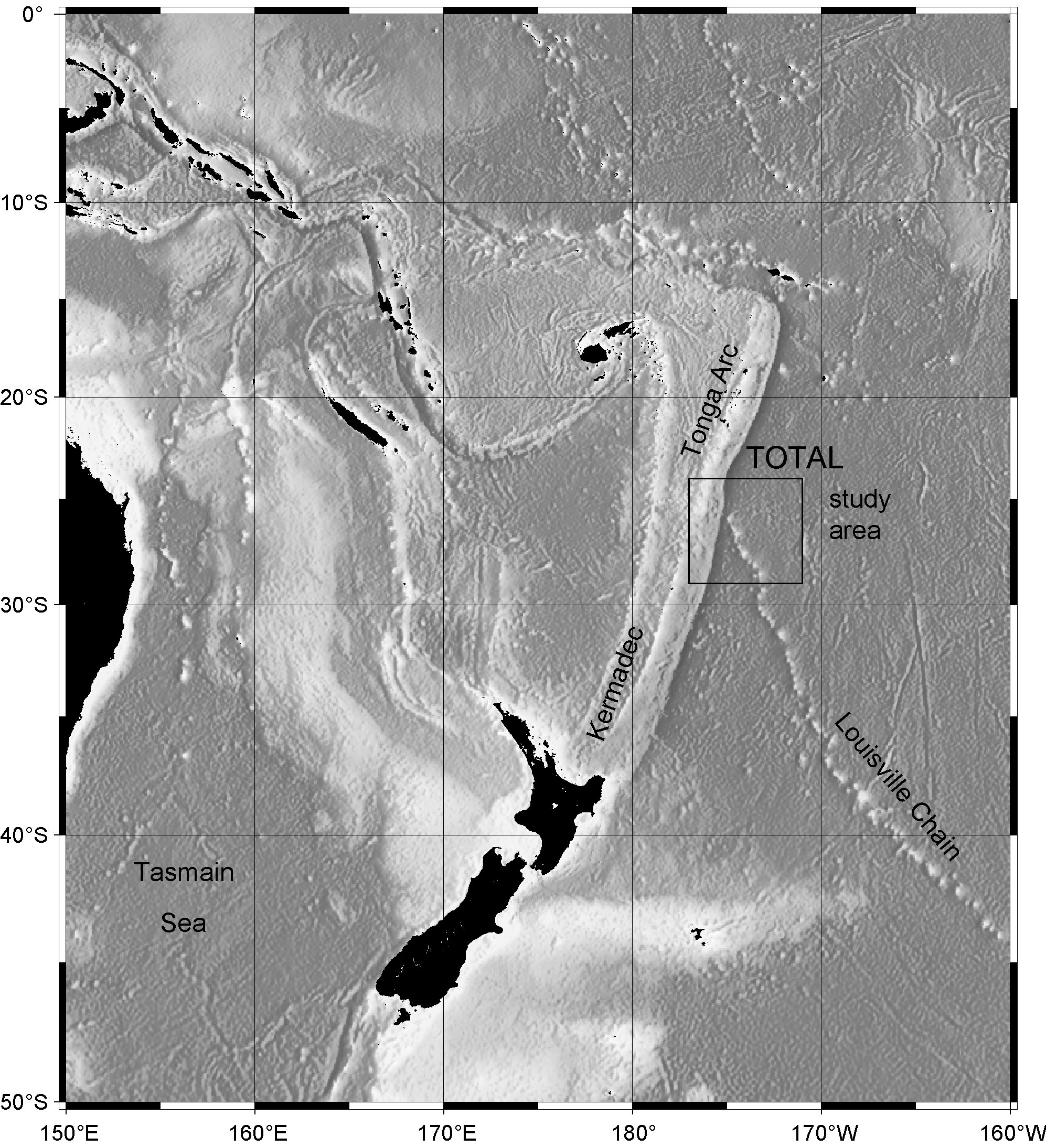
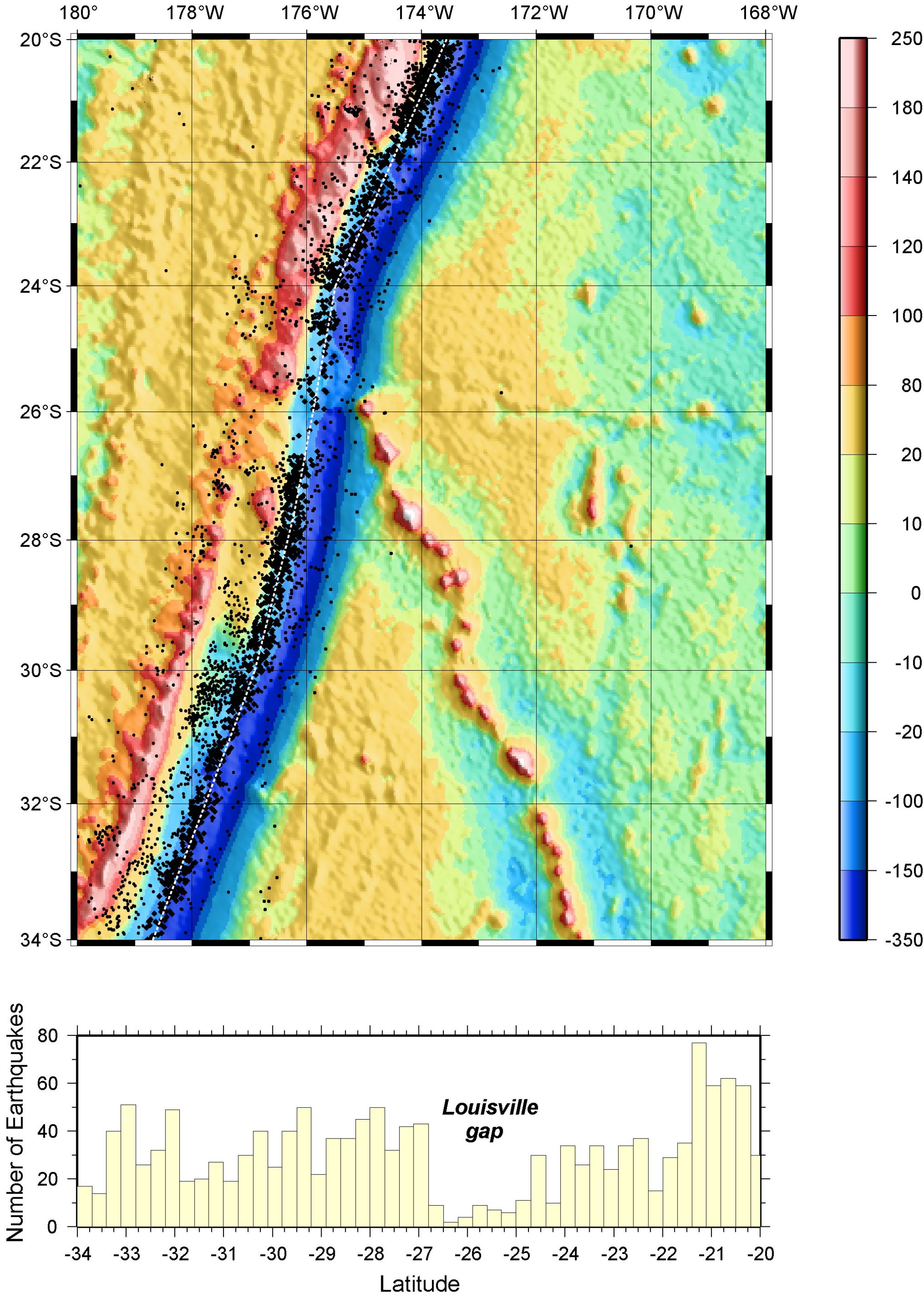
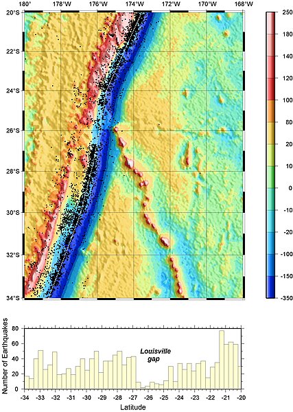
Subduction zones are the seismic most active regions of the world. Particularly thrust faulting earthquakes in the seismogenic coupling zone at a depth of approx. 10-40 km constitute a great hazard for the people living in coastal regions. At the Tonga trench – where the Louisville hotspot track is subducted – occurs a major seismic gap. The lack of teleseismic detectable earthquakes indicates the presence of a potential seismogenic asperity, which can lead to a great earthquake in the future (TOTAL – Tonga subduction zone Thrust earthquake Asperity at Louisville ridge). The seismic gap, however, is much wider than the characteristical diameter of seamounts running in the subduction zone. This suggests that other additional features realted to seamounts affect the coupling. The here proposed activities places us in a position to better understand the nature of asperities in subduction zones. Therefore seismic refraction and wide angle measurements completed with gravimetric and magnetic data and hydrographic mapping shall image the structure of the asperity and the position and structure of the already subducted volcanoes. A reference profile across Louisville Ridge running seaward of the subduction zone shall image the structure of the volcanoes and the hotspot swell so that the impact of sub crustal structures (root, underplating) to the subduction and seismogenic coupling can be evaluated.
A network of ocean bottom seismometers will measure the seismicity in the seismic gap as well as reference the seismicity in the region south of the gap. These activities will yield if coupling takes is perfect (100%) or if smaller earthquakes occur, which are well below the detectable threshold for global seismological networks.
A second aim is the systematic analysis of the erosion of the forearc caused by the subduction of the Louisville Ridge. The hydrographic mapping with SIMRAD shall image changes caused by tectonic processes (topography of the forearc and the incoming plate). Seismic refraction measurements are supposed to image the internal structure of the forearc (Vp, porosity) before, during and after Louisville Ridge eroded the margin wedge. A special focus constitutes the analysis of systematic changes of the fluid flows across the forearc. It is expected that different phases of erosion have a significant impact on the permeability of the continental slope for fluids. Fluid flow will be studied using heat flow measurements.
Das Schwerefeld der Erde (Freiluftanomalie abgeleitet aus der Satelliten-Altimetrie) im Untersuchungsgebiet und die globale Seismizität in der Region (Engdahl & Villasenor, 2002). Markant ist die seismische Lücke in der Region wo der Louisville-Rücken subduziert wird.
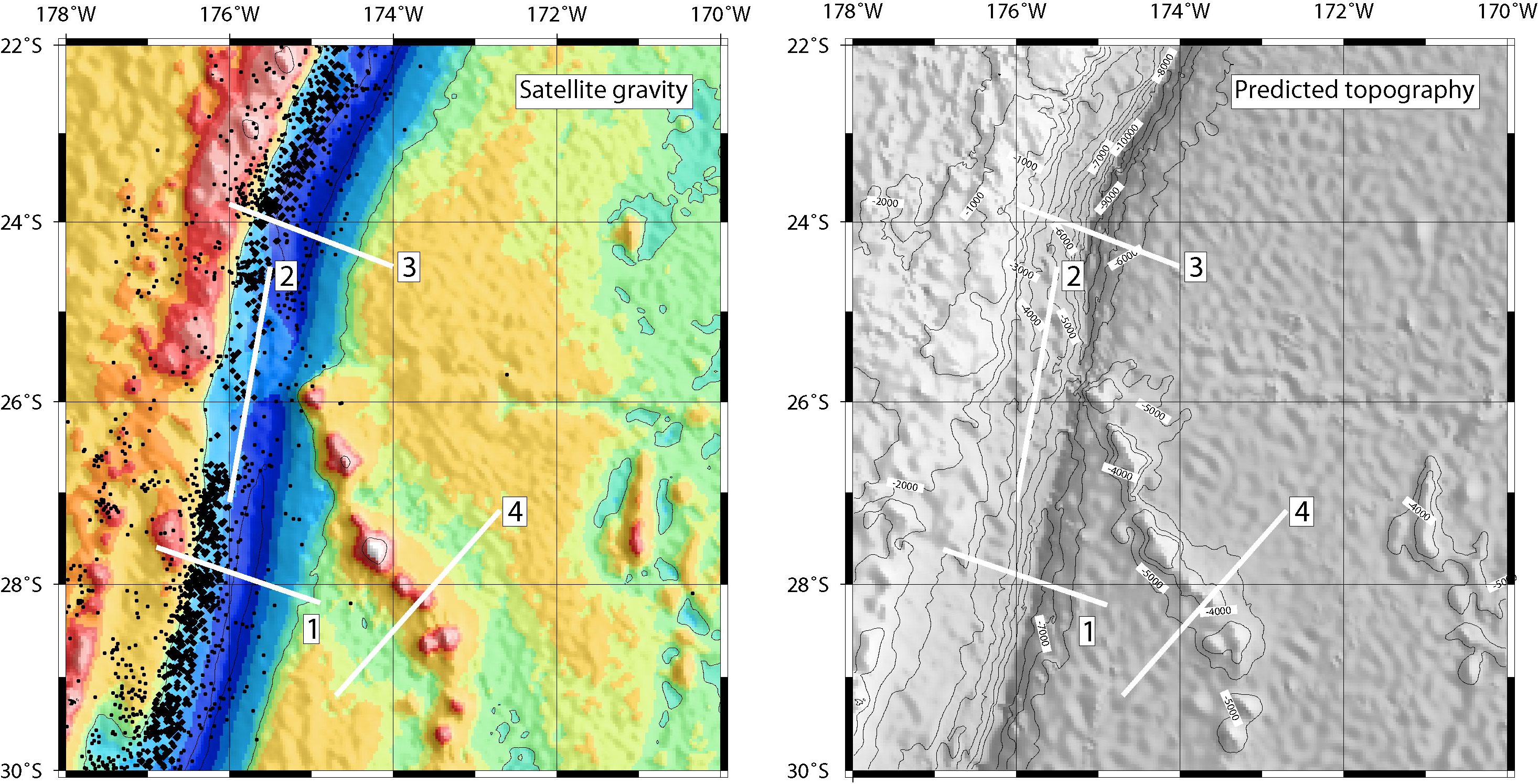
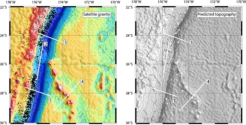
[Translate to English:] Lage der Profile im Arbeitsgebiet. Auf den Profilen 1, 2 und 3 sollen neben den tiefenseismischen Daten auch geothermische Messungen durchgeführt werden. Zusätzliche refraktionsseismische Daten werden über den Louisville Rücken gewonnen (4), um eine Referenzmessung der Krustenstruktur des zu subduzierenden Louisville Rücken zu haben. Zusätzliche geothermische Daten sollen in der Kollisionszone gesammelt werden. Entlang aller Profile werden auch gravimetrische und magnetische Messungen durchgeführt. Vor allem die Kollisionszone und die Korridore 1 und 3 sollen detailliert mit dem SIMRAD-Fächerecholot vermessen werden.