Driving the Climate: The Great Ocean Currents
Ocean currents transport gigantic amounts of heat around the globe. This makes them one of the most important driving forces of the climate. Since they react extremely slowly to changes, the effects of global change will be felt with certain delays, but over centuries. The imposing power of ocean currents have always been a well-kept secret among seafarers, passed on only orally. It took until the 17th century for the first systematic map of Atlantic ocean currents to be drawn. And it was not until the 1970s that global oceanographic data provided evidence of the so-called "global conveyor belt", an Earth-spanning current system through all oceans.
Ocean currents are driven by wind and differences in water density. Especially the near-surface currents are stimulated by an interaction of large-scale wind systems and the Coriolis force caused by the rotation of the Earth, as well as the land-sea distribution. Today we know that ocean currents also transport gigantic amounts of heat around the globe. They thus contribute to balancing the temperature differences between the equator and the poles and thus represent an important component in our climate system. On the other hand, our oceans buffer global warming: they absorb about one third of the anthropogenic greenhouse gas CO2.
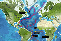
Thermohaline Circulation: The Global Conveyor Belt of Ocean Currents
One of the most important and well-known ocean currents in the Atlantic is the Gulf Stream. It transports warm water from the Gulf of Mexico along the American east coast northwards and across the Atlantic eastwards towards Europe. Here, the Gulf Stream becomes the North Atlantic Current. It has average surface speeds of up to six kilometres per hour and carries more water than all the rivers on earth combined. This transport of warm water to the coasts of Europe is partly responsible for the mild climate of northern Europe.
The warm water from the Gulf of Mexico cools down during its journey with the Gulf Stream towards the North Atlantic. The colder the water gets, the denser and heavier it becomes, and eventually sinks into the depths of the Greenland Sea and the Labrador Sea west of Greenland. This creates an additional forcing of the North Atlantic Current and an important component of the overall global ocean circulation. In the deep layers of the Atlantic, this creates an opposing, southward flow towards the Southern Ocean.
In the deep sea, the descended North Atlantic water flows towards the outlet of the South Atlantic as a cold deep current and is then fed into the Antarctic Circumpolar Current and transported to the Indian Ocean and the Pacific. The Southern Ocean Circumpolar Current runs around the entire globe and mixes the water masses of the three adjacent oceans. From there, the water masses move northwards again into the various ocean basins and mix with the surrounding water. In the process, they rise into the layers near the surface.
Warm water from the Indian Ocean is carried around the southern tip of Africa via the Agulhas Current. It first spreads out in large eddies several 100 kilometres in diameter and down to a depth of 1,000 metres in the South Atlantic and is then transported across the equator towards the Caribbean. This completes the cycle of global ocean circulation, which has timescales of several hundred to thousands of years.
Convection: The Journey of Water Into the Depths
The way convection works: In the subpolar and polar regions, such as the Labrador Sea south of Greenland, cold salty seawater sinks. These water masses accumulate above the even denser deep water on their way south and continue to migrate towards the equator. Warmer water flows into the convection area in the upper ocean layers. Graphic: Christoph Kersten / GEOMAR
Nowhere else in the oceans does surface water sink into the depths as quickly as in the convection regions in the North Atlantic and Southern Ocean. And nowhere else do changes at the sea surface or in the atmosphere make themselves felt in the interior of the ocean as quickly as here - for example, the increasing carbon dioxide concentration in the water. Convection connects two areas of the ocean that are different from each other: the layers near the surface, which are in contact with the atmospheric wind, radiation and precipitation, and the deep areas of the ocean. At the top, currents, temperatures or salinity fluctuate within weeks or months. At depth, on the other hand, environmental conditions tend to change over the course of decades or even centuries. In the warm ocean regions of the tropics and subtropics, there is no exchange between surface and depth comparable to convection. The warm surface water has a relatively low density and therefore floats as a warm surface layer on the deeper colder water masses. Both layers are clearly separated from each other. They also hardly mix. Instead, where they touch, there is a strong temperature and thus density gradient, which hinders the penetration of heat into the depths. Finally, in very warm ocean regions such as the western equatorial Pacific, there is hardly any mixing, but towards the poles the oceans are more mixed and less stratified. Since there is no clear temperature and density gradient, changes at the sea surface there can penetrate into the interior of the ocean. The convection areas, however, remain the express lift into the deep.
More information on this topic in World Ocean Review 1:
"The great ocean currents – the climate engine"
Research News: Ocean Currents