Prof. Heidrun Kopp
Tel.: +49 431 600 2334
Dr. Dietrich Lange
Tel.: +49 431 600 2324
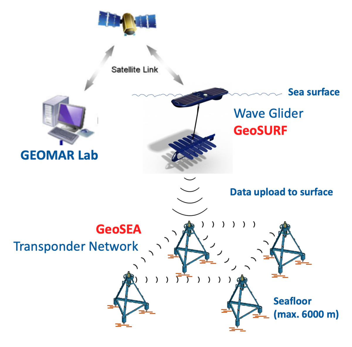
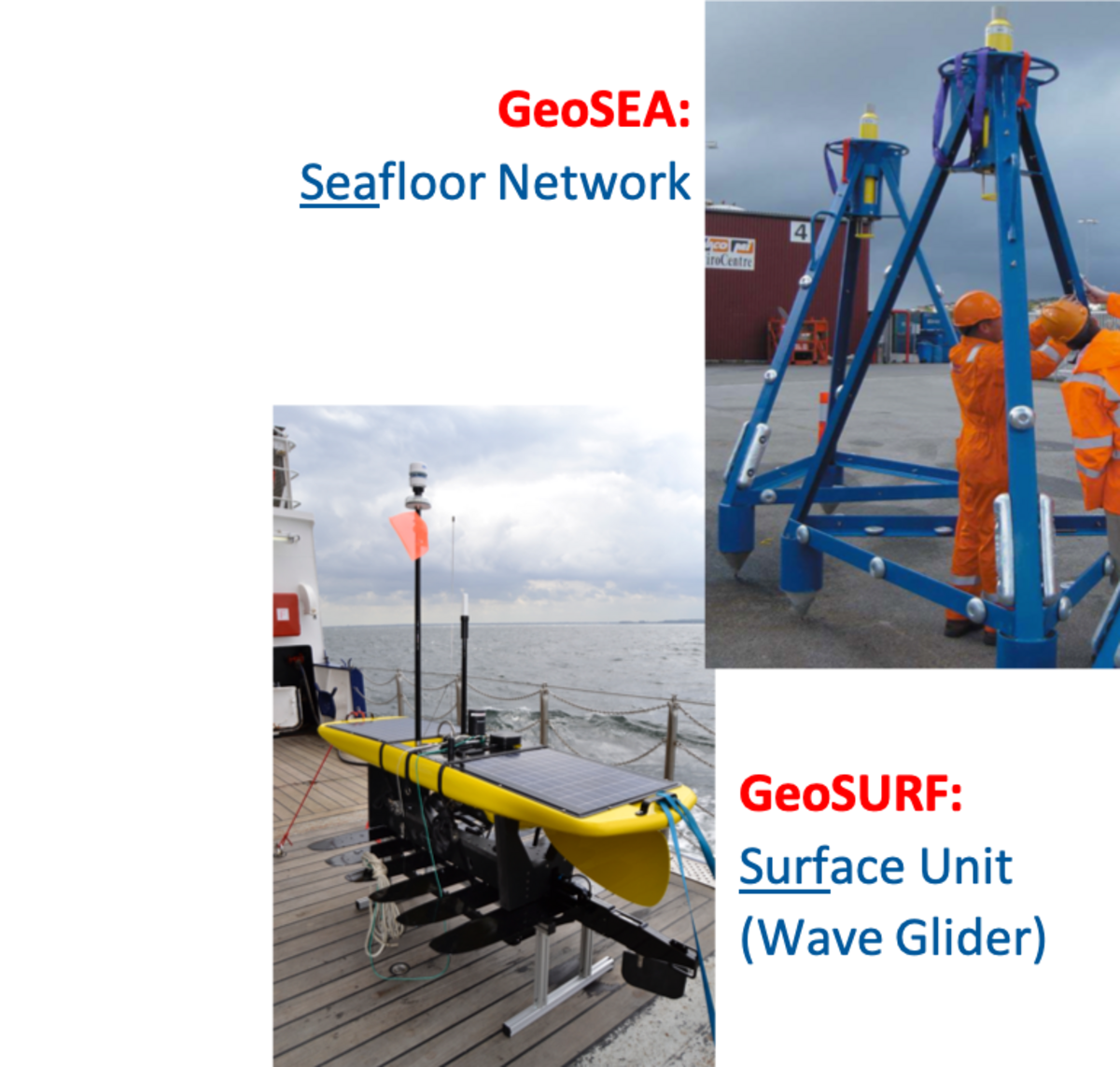
The GeoSEA (Geodetic Earthquake Observatory on the Seafloor) Array is an autonomous, mobile network of seafloor mounted stations that detect any active deformation of the underlaying seafloor. The GeoSEA network consists of two major, independent components: 1. GeoSURF, the Surface unit and 2. GeoSEA, the actual Seafloor Network, a network of transponders at the seafloor (Fig. 1 and 2).
GeoSEA itself consists of numerous, acoustically communicating ocean bottom stations (nodes). The relative distance of stations is calculated from the travel times of the emitted pings from one station to another. Any variation of these travel times during the length of the experiment are due to deformation. Thus, the deformation occurring within the spread of the network can be quantified by the travel time differences. In addition, mounted pressure sensors measure the hydrostatic pressure, improving the quantification of vertical deformation. Due to the expected minuteness of the deformation (several cm/year), undertaken experiments must extend over several years, imposing high requirements on the batteries, data recorder and data transfer mechanism of the stations, which have to remain at the seafloor for the length of the experiment.
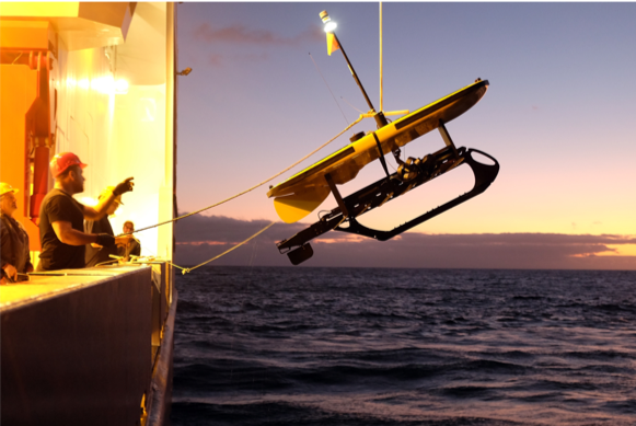
To allow the monitoring of the station’s state at the seafloor, the wave glider GeoSURF (Videolink) was integrated into the system. Its precise function lies in autonomously monitoring the seafloor station’s state of health, and in downloading the seafloor station’s data via modem and subsequently transferring the data to the lab using Iridium communication (Fig. 3).
Transponders, which function down to a depth of 6000 m produced by the company SONARDYNE Ltd (https://www.sonardyne.com/product/autonomous-monitoring-system/) were chosen for GeoSEA. The AMT (Autonomous Monitoring Transponder)-devices are acoustic transponders, with a horizontal accuracy of <15 mm. A pressure sensor is mounted on to the AMT-devices, measuring vertical deformation with a precision of 0.0001% based on changes in the hydrostatic pressure. An additional clinometer with an accuracy of 1° is integrated into the systems and used to determine the subsidence properties of the devices. Moreover, all devices are equipped to measure temperature and sound velocity, hence a calibration is possible during the experiment.
Thus, the system can not only measure horizontal distances, determined acoustically with guarantied sub-cm accuracy over distances of 2 km, but also vertical distances with the help of integrated pressure sensors. The measured vertical and horizontal high accuracy distances can easily be translated into deformation, making the device ideal for tectonic studies.
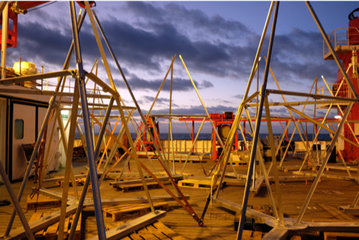
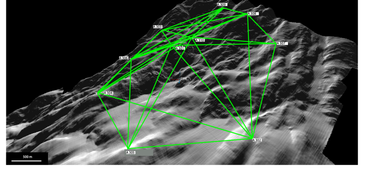
If necessary (e.g. seafloor topography), GeoSEA-stations can be mounted on steel tripods that can reach a height of up to 4 m (Fig. 4). These tripod-mounted GeoSEA-stations can be deployed using a deep-sea wire and a patented method involving a combination of floats, weights and positional transponders (Kopp et al., 2017). This allows the installation of larger networks (Fig. 5) as achieved at the continental margin of Chile (see article in Nature: https://www.nature.com/news/the-fight-to-save-thousands-of-lives-with-sea-floor-sensors-1.22178) without cost-intensive missions involving deep sea robots.
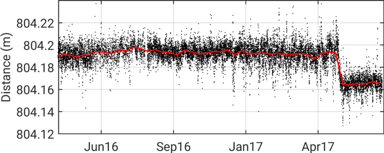
The feasibility of the method and its installation are described in Petersen et al, 2019 in detail. The GeoSEA-Network is known to have produced the worldwide first record of a ‘slow slip event’ at a volcano flank (Fig. 6) (Urlaub et al., Sci. Adv. 2018) and to have measured the stress field at the North-Anatolian Fault in the Marmara-Sea (Lange et al., Nat. Comm., 2019).
D. Lange, H. Kopp, J.-Y. Royer, P. Henry, Z. Cakir, F. Petersen, P. Sakic, V. Ballu, J. Bialas, S. Özeren, S. Ergintav, L. Géli, Interseismic Strain Build-up on the Submarine North Anatolian Fault Offshore Istanbul, NatureComm, 10:3006, doi:10.1038/s41467-019-11016-z, 2019.
F. Petersen, H. Kopp, D. Lange, K. Hannemann, M. Urlaub (2019), Invited Review Article: Measuring tectonic seafloor deformation and strain-build up with acoustic direct-path ranging, J. Geodyn., 124, 14-24, 10.1016/j.jog.2019.01.002.
Sakic, P., Ballu, V., Piete, H., Royer, J.-Y., Kopp, H., Lange, D. , Petersen, F., Özeren, M. S., Ergintav, S., Géli, L., Henry, P., Deschamps, A., 2016. First insights on motion across the underwater Istanbul-Silivri segment of the North Anatolian Fault: results of 6 months of seafloor acoustic ranging. Geophys. Res. Lett., doi: 10.1002/2016GL069600.
Urlaub, M., Petersen, F., Gross, F., Bonforte, A., Puglisi, G., Guglielmino, F., Krastel, S., Lange, D., and Kopp, H. (2018). Gravitational collapse of Mount Etna's southeastern flank, Science Advances, 4 (10), eaat9700, DOI: 10.1126/sciadv.aat970
Kopp, H., Lange, D., Steffen, K. P. und Petersen, F. Antragsteller/Inhaber: GEOMAR Helmholtz-Zentrum für Ozeanforschung Kiel (2017) Vorrichtung zur lösbaren Verbindung eines Drahtes und Verfahren zum Ausbringen des Gerätes in ein Gewässer mit der Vorrichtung. DE 102016107558 A1 2017.10.26 (Patent)
Kopp, H., Lange, D., Hannemann, K., Krabbenhoeft, A., Petersen, F. und Timmermann, A., eds. and Scientific Crew SO244-II (2016) RV SONNE Fahrtbericht / Cruise Report SO244/2, GeoSEA: Geodetic Earthquake Observatory on the Seafloor, Antofagasta (Chile) – Antofagasta (Chile), 27.11.-13.12.2015. . GEOMAR Report, N. Ser. 034 . GEOMAR Helmholtz Centre for Ocean Research, Kiel, 86 pp. DOI 10.3289/GEOMAR_REP_NS_34_2016 <http://dx.doi.org/10.3289/GEOMAR_REP_NS_34_2016>.
Timmermann, A., Investigation of cold water events at the bottom of the Sea of Marmara from November 2014 to April 2016, 42 pp, Christian-Albrechts-University of Kiel, Bachelor thesis, 2016.